How do you move through Tempelhof? Since the Middle Ages, a busy road ran along what is now the “Te-Damm”. Where merchants used to drive to Dresden, commuters now travel between the city center and the surrounding area.
“Traffic developments over time”
Car, metro, bicycle – or would it be better to walk? Andreas Jüttemann, an urban historian from Berlin, discusses ongoing changes and asks how traffic influences the city and vice versa.
Audio transcription
Here you will find the podcasts audio transcription >>
My name is Andreas Jüttemann, and I’m a historian specialising in cities, transportation and medicine. Tempelhofer Damm is part of a federal roadway, the B96. It already had number 96 in the Weimar Republic as a long transregional road connecting Zittau in Saxony with Sassnitz on Rügen.
A milestone in Berlin’s transportation system was the approval of a road development plan in 1927. It was the first plan to specify an overall network of roads for Berlin, not only for motorised vehicles but also carriages and cyclists. Tempelhofer Damm was part of it. A novel part of this plan was the introduction of expressways. In 1927 there weren’t yet any priority roads where vehicles had the right of way. They slowly started to be built in 1929. Before then, in the mid-1920s, everyone had to stop at all the crossroads, which meant that traffic flowed very slowly. The idea of roads without intersections, or priority roads, was relatively old. The first candidates included Clayallee in Zehlendorf, Bundesallee in Wilmersdorf and Kantstraße in Charlottenburg. Tempelhofer Damm in Tempelhof was added later. The aim was to have high levels of traffic concentrated on these big arteries. The roads were also supposed to have standardised widths. Trams were to run down the middle of the roads and be as undisturbed by motorised vehicles as possible. The road development plan of 1927 was approved by the Berlin government’s civil engineering office. It called for spending 18 million Reichsmarks annually for the next 15 years to develop the road system. The Great Depression of 1929 held up work for a few years. However, from today’s perspective the plan was a foundational element in Berlin’s urban transport planning, also and especially for the period after the second world war. There were some utopian ideas in 1929 too, such as elevated roads in the centre of the city, and some of the radial roads like Tempelhofer Damm were also supposed to be elevated. The network was to be 50 kilometres long, but there was a shortage of funds especially in the 1920s, and utopian ideas of this type were not put into practice. Which might be a good thing!”
It took only two years to develop the plans for an overall road network in Berlin, which is a very short period of time by today’s standards. In 1950 a general road plan was approved, calling for four bypasses and a ring road. It laid the foundation for later autobahn and main route planning, especially in West Berlin. Residential buildings that stood in the way of the planned routes were promptly declared redevelopment areas and torn down.
West Berliners were delighted with the first autobahn openings. With the student movement in 1968, however, and when the first autobahn segments began dividing entire neighbourhoods, they increasingly questioned whether that was really what they wanted. Ever more citizens’ groups became active. Protests were held, and by the 1980s autobahn openings attracted more big demonstrations than celebrations like those in the early euphoric planning period. The oil crisis of 1973 showed the dangers of excessive dependence on cars. Transport planners in West Berlin always considered the possibility of reunification, meaning that all the roads leading from outer districts into the city centre should later be able to be extended across the city’s borders.
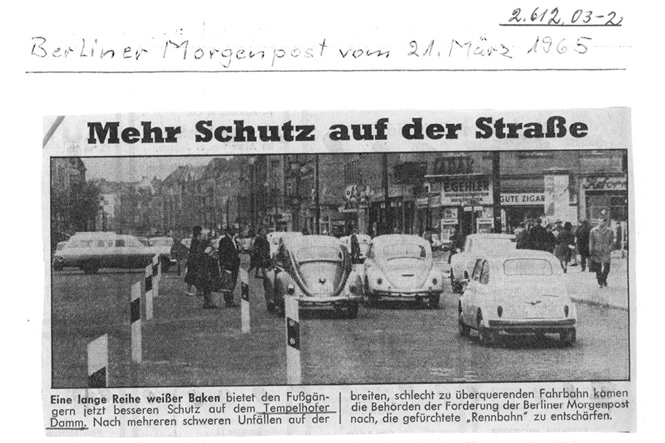
Tempelhofer Damm saw about 42,000 vehicles a day in 2020. This part of the B 96 links Berlin’s centre with its periphery. Today it is used by bicycles, cars, buses and motorcycles, but it already had high levels of traffic in the 19th century. Starting in 1838, the highway from Berlin to Dresden passed through Tempelhof’s village green on its way south. A pub has stood at this crossroads since the Middle Ages. Its owners all benefited from the stream of travellers. At the time of the Knights Templar, a watchtower likely stood across from the pub on the grounds of the Hahnehof. The Hahnehof was a farmstead that belonged to the Templars but lay outside the walls of their compound. Today Tempelhofer Damm is both a thoroughfare and a destination. Commuters and transport companies use it just as much as residents, visitors and delivery services. Traffic levels have triggered debate and disagreement. Living space and major arteries come together here, representing different needs of the community.
From horses to omnibuses
Traffic levels on Tempelhofer Damm were already causing complaints back at the turn of the twentieth century. The main disturbance for residents then, however, was the flow of visitors on daytime excursions. “Sixty to a hundred carriages filled the road at the pub, and woe to anyone seeking to pass with a loaded harvester or other vehicle […].“ Open horse-drawn carriages were connecting central Berlin with villages and other country attractions by 1830 already. Introduced shortly thereafter, horse-drawn omnibuses were running on a set timetable by 1847. A retrospective in the Teltower Kreisblatt in 1882 reveals the important role played by bus drivers. They ferried not only passengers but also post, medical products, meat, sugar and coffee. In the 1870s, horsecar lines were the main routes running from Kreuzberg to the centre of Berlin and passing through Tempelhof along the way. A special seasonal service operated when it snowed, with horses drawing sleds instead of wheeled carriages. One line was for the public and another for ambulances that took wounded soldiers to Berlin’s 2nd garrison facility, which would later become the Wenckebach hospital.
New forms of mobility on “T-Damm”
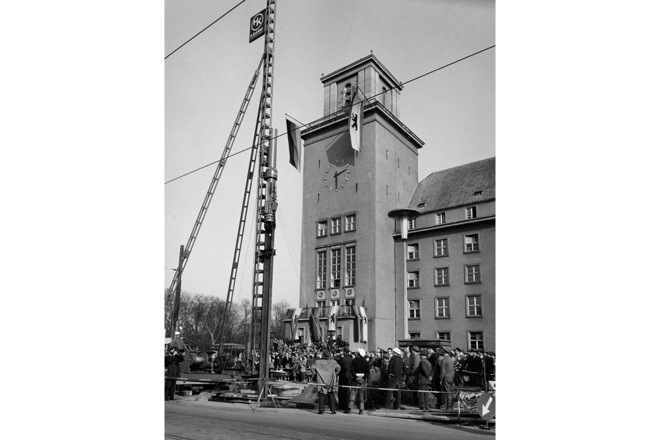
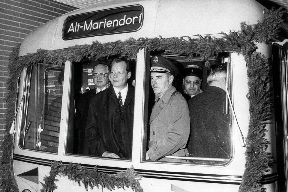
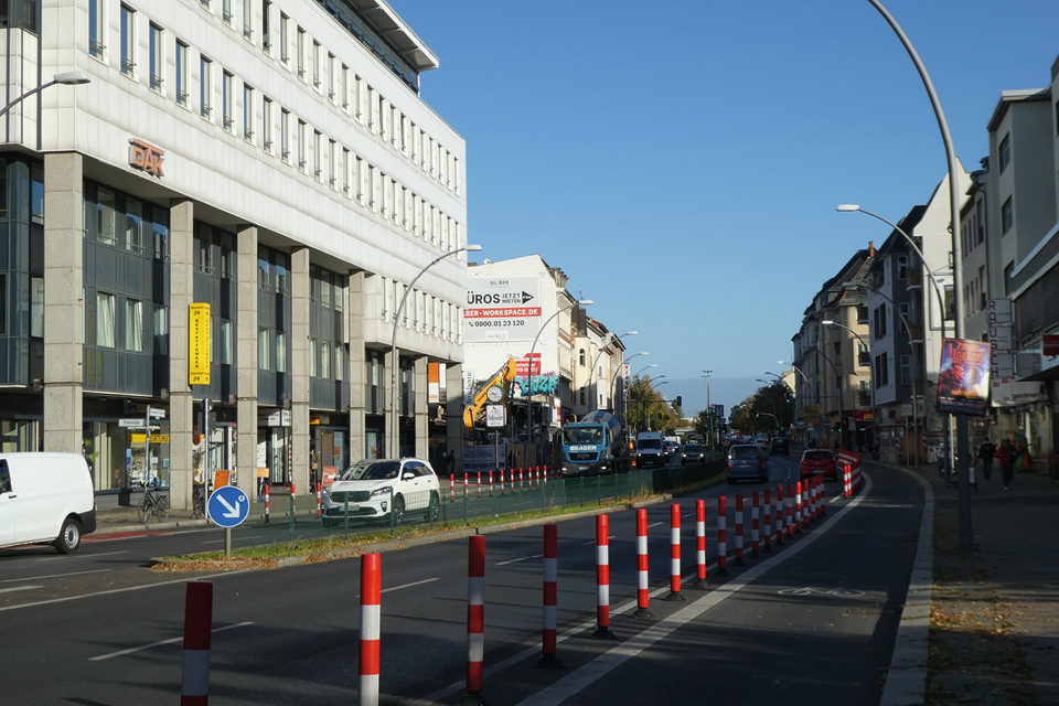
A new innovation took hold in the late 19th century. Electric streetcars and an expanded belt railway connected Tempelhof with the centre of Berlin. The underground metro reached Tempelhof in 1929. A new line to Alt-Mariendorf opened in the 1960s. Environment and climate groups are promoting not only public transportation but also bicycle-friendly policies. T-Damm is the site of a major infrastructure project. The Berlin Mobility Act of 2018 requires the city to have an additional 100 kilometres of bicycle paths by 2030. The bike paths on Tempelhofer Damm should also be safe. “Vision Zero” is the driving force behind these initiatives. The goal is to reduce traffic deaths and serious injuries. Residents are actively contributing their ideas and efforts to make traffic in Berlin safer and more climate-friendly. To ensure that goods can still be transported, ecological delivery options are being developed. Cargo bikes, pack stations, loading zones for motorised delivery vehicles, and disincentives for parallel parking are just some of the measures advocated by members of the alliance.